Lozere - Le Villard-Le-Malzieu-Ville Les trucs de Malzieu-Forain 14km 410m

RandoVal
User
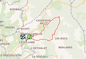

Length
13.6 km

Max alt
1353 m

Uphill gradient
468 m
Km-Effort
19.9 km

Min alt
954 m

Downhill gradient
468 m
Boucle
Yes
Creation date :
2018-09-12 19:09:00.436
Updated on :
2018-09-12 19:09:00.445
4h08
Difficulty : Easy

FREE GPS app for hiking
 SityTrail
IGN / Geographical institutes
SityTrail Plus
The world is yours!
About
Trail Walking of 13.6 km to be discovered at Occitania, Lozère, Le Malzieu-Forain. This trail is proposed by RandoVal.
Description
Randonnées entre Gévaudan et Margeride .
Départ du hameau Le-Villard-Le-Malzieu-Ville .
Beau sentier et belle forêt .
Sens horaire, version courte
Positioning
Country:
France
Region :
Occitania
Department/Province :
Lozère
Municipality :
Le Malzieu-Forain
Location:
Unknown
Start:(Dec)
Start:(UTM)
527933 ; 4968384 (31T) N.
Comments